
The Vancouver Cycling Map
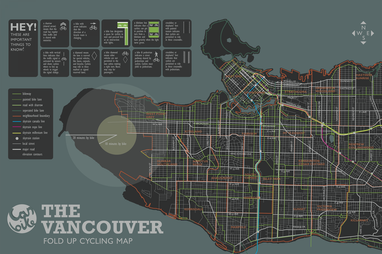
a bikelane box 3 indicates that a =o o cyclists can get in position to turn from a bikelane and crossbikes or a sharrow (shared arrow) means that the road has regular bike traffic and is shared with motorists. a bike with arrow indicates that the direction of a HEY! a bike box designates a space for cyclists to wait and proceed first at an intersection with lights. elephants' feet with painted texture indicates that cyclists are permitted to ride in these crosswalks. (W_E THESE ARE bicycle route is changing. IMPORTANT have priority when the light turns green. THINGS TO KNOW! a bike diamond means other vehicles are not a bike & pedestrian indicates a street crossbikes or a bike with vertical lines indicates that the traffic signal is activated by sensors and shows cyclists| where to line up wheels to trigger the signal change. || a diamond means the lane is eserved elephants' feet for special vehicles, like buses, carpools, and bicycles. Cyclists may ride in these marked or signed reserved lanes. permitted in the lane unless making a right turn. Buses may stop for passengers. pathway shared by pedestrians and O cyclists. Cyclists must yield to pedestrians. indicates that cydists are permitted to ride in these crosswalks with pedestrians. HASTINGS SUNRISE DAVIE ST POWELL ST CORDOVA ST DUNDAS ST HASTINGS ST STRATHCO bikeway PRIOR ST painted bike lane TERMINAL A road with sharrow AVE %24 seperated bike lane E 1 AVE WEST POIN neighbourhood boundary GREY skytrain canada line W 12 AVE W BROADVWAY E BROADWA skytrain expo line skytrain millenium line skytrain station E 12 AVE FAIIRVIEW 20 minutes by bike E 16 AVE! local street 10 minutes by bike RENFRE major road elevation contours KING EDWARD AVE ENCIGNTO UNBAR DUTHLANi W 33 AVE KINGSWAY E33 AVE SOUT CAMBIE W41 AVE 41AVE DAKBIDCE W 49 AVE E 49 AVE FKERRISDALE SUNSET FRASERVIEW W 57 AVE E 54 AVE E 57 AVE KILLARNEY VANCOUVER MARPOLE MARINE DR FOLD UP CYCLING MAP M CAMOSUN ST DENMAN S KERR ST CHAMPLAIN CR
The Vancouver Cycling Map
Source
Unknown. Add a sourceCategory
SportsGet a Quote


