
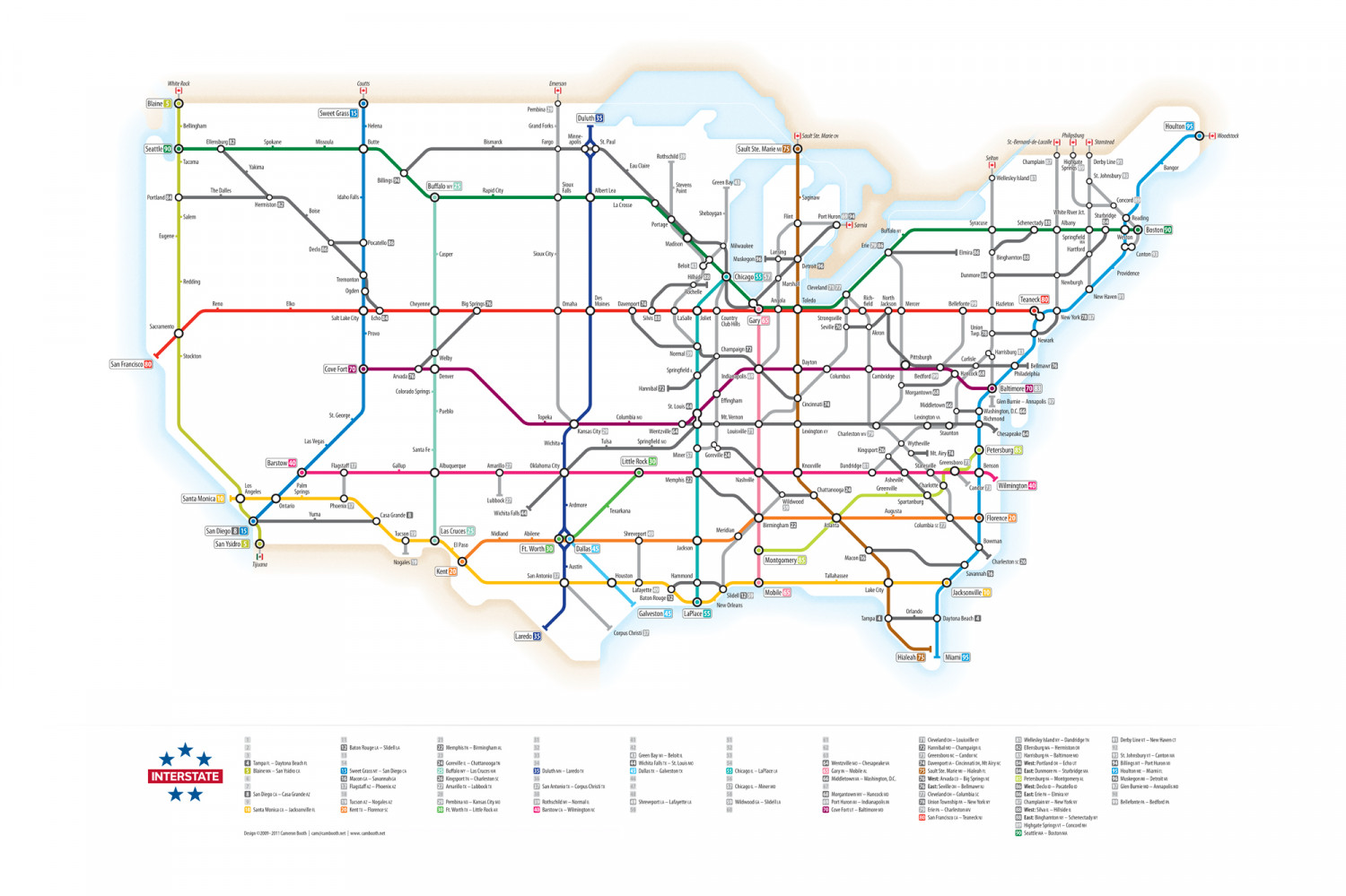
U.S. Interstates as a Subway Map
White Rock Coutts Emerson Blaine 50 Sweet Grass 15 Pembina 29 Duluth 35 -Bellingham Helena Grand Forks Houlton 95 Minne- apolis CSault Ste. Marie oN St-Bernard-de-Lacolle (-) Philipsburg O Stanstead O Woodstock Ellensburg 82 Spokane Missoula Butte Bismarck Fargo St. Paul Seattle 90 O Sault Ste. Marie Mi 75 O Rothschild 39 Selton Tacoma Champlain 87 Highgate Springs 89 Eau Claire Derby Line 1 Bangor Yakima Billings 94 O Weleley Island St. Johnsbury 93 Buffalo wy 25 Fals Stevens Point Green Bay 3 The Dalles Rapid City Albert Lea Portland a O Idaho Falls Saginaw Concord Hermiston 32 La Crosse Boise Sheboygan White River Jct. Port Huron 69 94 O (Sarmia Sturbrido 84 Salem Flint O Reading OO Boston 90 Portage Sутасuse Schenectady Albany Buffalo w Eugene Springfield Hartford OPocatello 86 Madison Erie 79 86 Milwaukee Dedo 86 Laniing Muskegon 96 FO O Detroit 96 Casper Sioux City | Elmira 6 O Canton 93 Binghamton 83 Beloit 3 O Hillside 88 O Chicago 55 57 o Dunmore 3 O Providence -Redding Tremonton Marsha leveland 71n Newburgh Ogden O Rochelle Des New Haven 91 Rich- field Jackson Mercer North Big Springs 70 O Angola Toledo Bellefonte 99 Hazieton Teaneck 80 Reno Elko Cheyenne Omaha Moines Davengort 7 Silvis 88 LaSalle Joliet Country Club Hils Gary 65 Strongsville Seville 76 O New York 7887 Salt Lake City Echo 84 Sacramento Provo Union Twp. 78 O Akron Newark Champaign 72 Stockton Normal 39 Pittsburgh Welby Carlisle Harrisburg San Francisco 80 Dayton Cove Fort 70 O Springfield O Hancock 68 O Bellmawr 76 Philadelphia Arvada 76 Denver Indjanpolis 69 Columbus Cambridge Bedford 99 O Baltimore 70 83 Glen Burmie - Annapolis 7 OWashington, D.C. 66 Richmond Colorado Springs Hannibal 2- Morgantown 68 Effingham Cincinnati 4 Middletown 66 St. Louis 44 Pueblo St. George Topeka Columbia mo Mt. Vernon Lexington va Kansas City 29 Wentzville 64 Louisville 71 Lexington Charleston wv 79 Chesapeake 64 Staunton Las Vegas Wichita Tulsa Springfield wo O Wytheville O Mt. Airy 0 Greensboro 3 Santa Fe Kingsport 26 O Petersburg 85 Miner 57 Goreville 24 Barstow 40 Little Rock B0 Statesvile Flagstaff 7 Gallup Albuquerque Amarillo 27 Oklahoma City Knoxville Dandridge 81 Benson Memphis 22 Nashville Asheville Charlotte O Los Angeles Palm Springs Candor 73 Wilmington 40 Chattanooga 20 Greenville Santa Monica 10 Lubbock 27 Spartanburg Augusta Ontario Phoenix 17 - Ardmore Wildwood Yuma Casa Grande 8 Wichita Falls Texarkana O Florence 20 Birmingham 2 Atlanta Columbia sc 27 San Diego 8 15 San Ysidro 5 O Tucson 19 Las Cruces 25 Midland Shreveport (19 Meridian Abilene Bowman El Paso Ft. Worth 30 Dallas 45 Jackson Nogales 19 Montgomery 85 Macon 16 Charleston sc 26 Tijuana -Austin Kent 20 San Antonio 37 Houston Hammond Savannah 16 Tallahassee Lafayette 19 Baton Rouge 12 Mobile 65 Slidell 12 59 Lake City Jacksonville 10 New Orleans Galveston 45 LaPlace 55 Orlando Tampa a0 O Daytona Beach 4 Laredo 35 Corpus Christi 87 Hialeah 75 1 Miami 95 7 Clevelandon - Louisville r 2 Hannibal Mo - Champaign 73 Greensboro N -Candor N 74 Davenport iA- Cincinnati on, Mt Airy N 75 Sault Ste. Marie M- Hialeah F 76 West: Arvada co - Big Springs NE 76 East: Seville on - Bellmawr 7 Clevelandon - Columbia sc 78 Union Township PA – New York wY 79 Erie A - Charlestonw 80 San Francisco CA - TeaneckN 31 32 33 41 42 43 Green Bay w - Beloiti 44 Wichita Falls TX- St. Louis MO 45 Dallas t- Galveston X 46 47 48 49 ShreveportLA - Lafayette LA 51 61 62 63 A Wentzville Mo - Chesapeakea 65 GaryIN- Mobile A 6 Middletowna- Washington, D.C. 91 Derby Line v - New Haven Ct 92 3 St. Johnsburyvt - Canton MA 94 Billings MT - Port Huron M 95 Houlton ME - Miami 96 Muskegon M - Detroit MI 97 Glen Burnie Mo - Annapolis MD 98 99 Bellefonte - Bedford A 11 12 Baton Rouge LA - Slidell LA 13 14 21 22 Memphis IN - Birmingham A 23 24 Goreville - Chattanooga TN 25 Butfalo wy - Las Cruces NM 26 Kingsport IN - Charleston 27 Amarille x - Lubbock TX 28 29 Pembina No - Kansas City wo 30 Ft. Worth X - Little Rock AR 81 Wellesley Island w - Dandridge TN 82 Ellensburg WA - Hermiston OR 83 Harrisburg A – Baltimore MO 84 West: Portland or - Echo ur 84 East: Dunmore PA – Sturbridge MA 85 Petersburg va - Montgomery AL 86 West: Declo o- Pocatello o 86 East: Erie M- Elmira NY 87 Champlain NY - New York wY 88 West: Silva-Hilside 88 East: Binghamton w - Schenectady NY 89 Highgate Springs VI- Concord 90 Seattle wa - Boston MA 52 4 Tampa - Daytona Beach R 5 Blainew - San Ysidro cA 53 54 55 Chicago-LaPlace LA 15 Sweet Grass M - San Diego CA 16 Macon GA - SavannahGa 17 Flagstaff az - Phoenix Az 35 Duluth MN- Laredo X 36 37 San Antonio T- Corpus Christi Tx 38 39 Rothschild w- Normal 40 Barstow CA - Wimington INTERSTATE 57 Chicago- Miner MO B San Diego CA - Casa Grande A 68 Morgantown wy -Hancock Mo 9 Port Huron M - Indianapolis IN 70 Cove fort ut - Baltimore MO 18 58 19 Tucson A- Nogales A 20 Kent X- Florence s 59 Wildwood Ga - Slidellia 60 10 Santa Monica a- Jacksonville 50 Design O2009-2011 Cameron Booth camcambooth.net www.canbooth.net
U.S. Interstates as a Subway Map
Source
http://www.c...chives/641Category
TransportationGet a Quote


