
The Perilous Journey of the Northern Gateway Pipeline
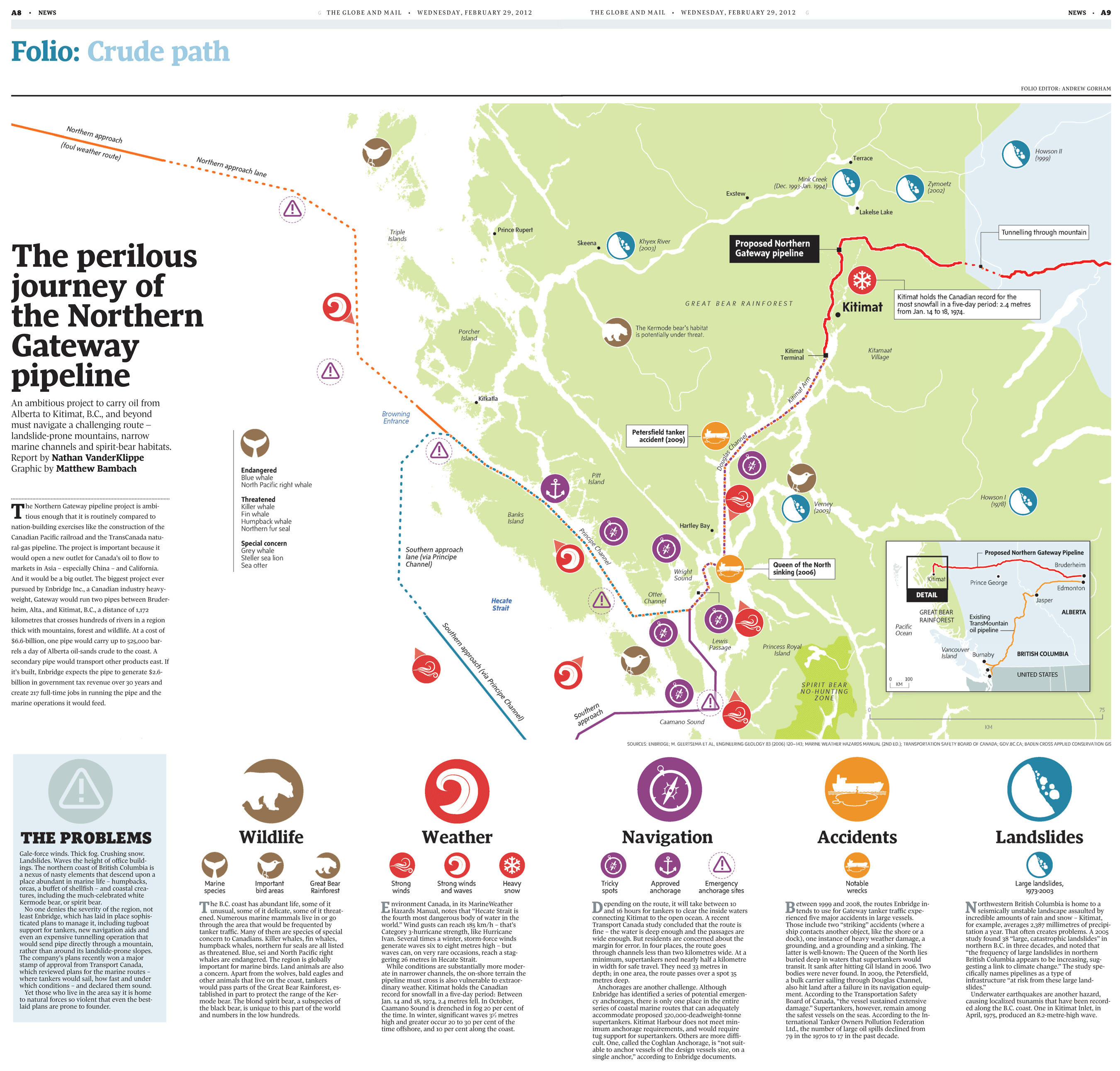
A8 NEWS G THE GLOBE AND MAIL . WEDNESDAY, FEBRUARY 29, 2012 THE GLOBE AND MAIL . WEDNESDAY, FEBRUARY 29, 2012 NEWS A9 Folio: Crude path FOLIO EDITOR: ANDREW GORHAM Northern approach (foul weather route) Howson II (1999) Northern approach lane Terrace Mink Creek (Dec. 1993-Jan. 1994) Zymoetz (2002) Exstew Lakelse Lake Prince Rupert Triple Islands Tunnelling through mountain Khyex River (2003) Proposed Northern Gateway pipeline Skeena The perilous journey of the Northern Gateway pipeline Kitimat holds the Canadian record for the most snowfall in a five-day period: 2.4 metres from Jan. 14 to 18, 1974. GREAT BEAR RAINFOREST Kitimat The Kermode bear's habitat Porcher İland is potentially under threat. Kitamaat Kitimat Terminal Village Kitkatla An ambitious project to carry oil from Alberta to Kitimat, B.C., and beyond must navigate a challenging route - landslide-prone mountains, narrow marine channels and spirit-bear habitats. Report by Nathan VanderKlippe Graphic by Matthew Bambach Browning Entrance Petersfield tanker accident (2009) Endangered Blue whale Pitt Island North Pacific right whale Howson I (1978) Threatened Killer whale Fin whale Humpback whale Northern fur seal Verney (2003) The Northern Gateway pipeline project is ambi- tious enough that it is routinely compared to Banks Island nation-building exercises like the construction of the Hartley Bay Canadian Pacific railroad and the TransCanada natu- Special concern Grey whale Steller sea lion Sea otter (23) ral-gas pipeline. The project is important because it • Southern approach • lane (via Principe • Channel) Proposed Northern Gateway Pipeline would open a new outlet for Canada's oil to flow to Queen of the North sinking (2006) Bruderheim markets in Asia - especially China - and California. Wright Sound And it would be a big outlet. The biggest project ever Kitimat Prince George pursued by Enbridge Inc., a Canadian industry heavy- Edmonton Otter Channel DETAIL weight, Gateway would run two pipes between Bruder- Hecate Strait Jasper heim, Alta., and Kitimat, B.C., a distance of 1,172 GREAT BEAR ALBERTA Existing TransMountain oil pipeline kilometres that crosses hundreds of rivers in a region RAINFOREST Pacific Ocean thick with mountains, forest and wildlife. At a cost of $6.6-billion, one pipe would carry up to 525,000 bar- Lewis Princess Royal Island Passage rels a day of Alberta oil-sands crude to the coast. A Vancouver Island Burnaby BRITISH COLUMBIA secondary pipe would transport other products east. If it's built, Enbridge expects the pipe to generate $2.6- UNITED STATES billion in government tax revenue over 30o years and 100 км SPIRIT BEAR NO-HUNTING ZONE create 217 full-time jobs in running the pipe and the marine operations it would feed. Southern approach Caamano Sound KM SOURCES: ENBRIDGE; M. GEERTSEMA ET AL, ENGINEERING GEOLOGY 83 (2006) 120-143; MARINE WEATHER HAZARDS MANUAL (2ND ED.); TRANSPORTATION SAFETY BOARD OF CANADA; GOV.BC.CA; BADEN CROSS APPLIED CONSERVATION GIS THE PROBLEMS Wildlife Weather Navigation Accidents Landslides Gale-force winds. Thick fog. Crushing snow. Landslides. Waves the height of office build- ings. The northern coast of British Columbia is a nexus of nasty elements that descend upon a place abundant in marine life - humpbacks, orcas, a buffet of shellfish - and coastal crea- tures, including the much-celebrated white Kermode bear, or spirit bear. No one denies the severity of the region, not least Enbridge, which has laid in place sophis- ticated plans to manage it, including tugboat support for tankers, new navigation aids and even an expensive tunnelling operation that would send pipe directly through a mountain, rather than around its landslide-prone slopes. The company's plans recently won a major stamp of approval from Transport Canada, which reviewed plans for the marine routes where tankers would sail, how fast and under which conditions - and declared them sound. Yet those who live in the area say it is home to natural forces so violent that even the best- (23) Important bird areas Great Bear Rainforest Strong winds Strong winds and waves Tricky spots Approved anchorage Notable wrecks Large landslides, 1973-2003 Marine Heavy Emergency anchorage sites species snow he B.C. coast has abundant life, some of it unusual, some of it delicate, some of it threat- ened. Numerous marine mammals live in or go through the area that would be frequented by tanker traffic. Many of them are species of special concern to Canadians. Killer whales, fin whales, humpback whales, northern fur seals are all listed as threatened. Blue, sei and North Pacific right whales are endangered. The region is globally important for marine birds. Land animals are also a concern. Apart from the wolves, bald eagles and other animals that live on the coast, tankers would pass parts of the Great Bear Rainforest, es- tablished in part to protect the range of the Ker- mode bear. The blond spirit bear, a subspecies of the black bear, is unique to this part of the world and numbers in the low hundreds. nvironment Canada, in its MarineWeather E Hazards Manual, notes that "Hecate Strait is the fourth most dangerous body of water in the world." Wind gusts can reach 185 km/h - that's Category 3-hurricane strength, like Hurricane Ivan. Several times a winter, storm-force winds generate waves six to eight metres high - but waves can, on very rare occasions, reach a stag- gering 26 metres in Hecate Strait. While conditions are substantially more moder- ate in narrower channels, the on-shore terrain the pipeline must cross is also vulnerable to extraor- dinary weather. Kitimat holds the Canadian record for snowfall in a five-day period: Between Jan. 14 and 18, 1974, 2.4 metres fell. In October, Caamano Sound is drenched in fog 20 per cent of the time. In winter, significant waves 3% metres high and greater occur 20 to 30 per cent of the time offshore, and 10 per cent along the coast. epending on the route, it will take between 10 and 16 hours for tankers to clear the inside waters connecting Kitimat to the open ocean. A recent Transport Canada study concluded that the route is fine - the water is deep enough and the passages are wide enough. But residents are concerned about the margin for error. In four places, the route goes through channels less than two kilometres wide. At a minimum, supertankers need nearly half a kilometre in width for safe travel. They need 33 metres in depth; in one area, the route passes over a spot 35 metres deep. Anchorages are another challenge. Although Enbridge has identified a series of potential emergen- cy anchorages, there is only one place in the entire series of coastal marine routes that can adequately accommodate proposed 320,0oo-deadweight-tonne supertankers. Kitimat Harbour does not meet min- imum anchorage requirements, and would require tug support for supertankers. Others are more diffi- cult. One, called the Coghlan Anchorage, is "not suit- able to anchor vessels of the design vessels size, on a single anchor," according to Enbridge documents. D etween 1999 and 2008, the routes Enbridge in- tends to use for Gateway tanker traffic expe- rienced five major accidents in large vessels." Those include two "striking" accidents (where a ship contacts another object, like the shore or a dock), one instance of heavy weather damage, a grounding, and a grounding and a sinking. The latter is well-known: The Queen of the North lies buried deep in waters that supertankers would transit. It sank after hitting Gil Island in 2006. Two bodies were never found. In 2009, the Petersfield, a bulk carrier sailing through Douglas Channel, also hit land after a failure in its navigation equip- ment. According to the Transportation Safety Board of Canada, "the vessel sustained extensive damage." Supertankers, however, remain among the safest vessels on the seas. According to the In- ternational Tanker Owners Pollution Federation Ltd., the number of large oil spills declined from 79 in the 1970s to 17 in the past decade. Northwestern British Columbia is home to a | seismically unstable landscape assaulted by incredible amounts of rain and snow - Kitimat, for example, averages 2,387 millimetres of precipi- tation a year. That often creates problems. A 2005 study found 38 "large, catastrophic landslides" in northern B.C. in three decades, and noted that “the frequency of large landslides in northern British Columbia appears to be increasing, sug- gesting a link to climate change." The study spe- cifically names pipelines as a type of infrastructure "“at risk from these large land- slides." Underwater earthquakes are another hazard, causing localized tsunamis that have been record- ed along the B.C. coast. One in Kitimat Inlet, in April, 1975, produced an 8.2-metre-high wave. D. laid plans are prone to founder. Kitimat Arm glas Channel Dougla e Channel Southern approach (via Principe Channel)
The Perilous Journey of the Northern Gateway Pipeline
Source
http://www.f...7418752184Category
EnvironmentGet a Quote


