Google: Maps & Earth Campaign
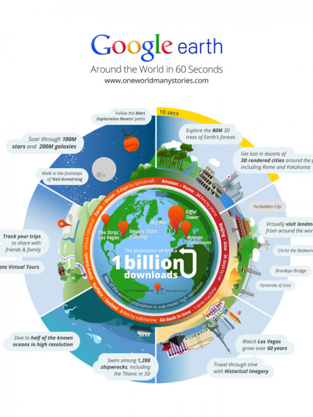
Google Sky 100 million stars and 200 million galaxies are visible through Google Sky, some of which have never been seen by the human eye. 255 Miles Above Earth Astronauts on the International Space Station, with no Internet access, use Google Earth portable technology to get richer data about what they see hundreds of miles above the Earth. The Moon and Mars No need to be ground bound. You can explore the Sky. Moon & Mars from Google Earth Take it With You US Air Force pilots and operators can bring the Google Earth portable in the cockpit with them, providing them with an integrated view of weather, mapping information, & airspace boundary details for flight missions. Customize Your Earth Researchers at Utah State University used a blimp with a digital camera hundreds of feet off the pround to capture current, high resolution images that can easily be incorporated into Goegle Earth. Inside or Out Google Maps 6.0 for Android makes hundreds of millicns of square feet of floor plans available in the palm of your hand. Maps Everywhere 600,000+ active sites/domains use the Google Maps API. DOWNLOADS LO0D0,000 Geo Locate More than 20% of searches on Google.com are related to location. Go Mobile Today more than S0% of global Google Maps usage is mobile. One Billion Served Google Earth has been downloaded more than 1 Biion times since first introduced in 2005. Mobile Maps There are 250M active monthly Google Maps for mobile users acress platforms and devices worldwide. From Here to There Google Transit is awailable in more than 400 regions/territories worldwide -------- A Real Time Saver More than 10M people use Google Maps Navigation, driving more than 128 miles a year with this tool. With the route around traffic feature, users save twe years per day. Dive, Dive, Dive! In Kelly Lake, British Columbia, a team of scientists put Google larth portable techoolory in a deen sea submecsible hundreds of feet below water to create a 3-0 model of the lake's bettom. Real-Time Data US Army Corps of Engineers flood response teams capture video, photos, and other data on mobile phones, which can be shared in near real time with decision makers via Google Maps. Go Deeper 5% of the ocean has been explored in 200m resolution. Get accurate, current maps into the hands of your people-wherever they need them. Global Traffic Google provides live traffic data in more than 30 countries, with ceverage of highways, streets, and more than 200 major ities. Google Learn more at www.google.com/federal. Request extra copies of this poster from [email protected]. bluetext Google Google Sky 100 million stars and 200 million galaxies are visible through Google Sky, some of which have never been seen by the human eye. 255 Miles Above Earth Astronauts on the International Space Station, with no Internet access, use Google Earth portable technology to get richer data about what they see hundreds of miles above the Earth. The Moon and Mars No need to be ground bound. You can explore the Sky. Moon & Mars from Google Earth Take it With You US Air Force pilots and operators can bring the Google Earth portable in the cockpit with them, providing them with an integrated view of weather, mapping information, & airspace boundary details for flight missions. Customize Your Earth Researchers at Utah State University used a blimp with a digital camera hundreds of feet off the pround to capture current, high resolution images that can easily be incorporated into Goegle Earth. Inside or Out Google Maps 6.0 for Android makes hundreds of millicns of square feet of floor plans available in the palm of your hand. Maps Everywhere 600,000+ active sites/domains use the Google Maps API. DOWNLOADS LO0D0,000 Geo Locate More than 20% of searches on Google.com are related to location. Go Mobile Today more than S0% of global Google Maps usage is mobile. One Billion Served Google Earth has been downloaded more than 1 Biion times since first introduced in 2005. Mobile Maps There are 250M active monthly Google Maps for mobile users acress platforms and devices worldwide. From Here to There Google Transit is awailable in more than 400 regions/territories worldwide -------- A Real Time Saver More than 10M people use Google Maps Navigation, driving more than 128 miles a year with this tool. With the route around traffic feature, users save twe years per day. Dive, Dive, Dive! In Kelly Lake, British Columbia, a team of scientists put Google larth portable techoolory in a deen sea submecsible hundreds of feet below water to create a 3-0 model of the lake's bettom. Real-Time Data US Army Corps of Engineers flood response teams capture video, photos, and other data on mobile phones, which can be shared in near real time with decision makers via Google Maps. Go Deeper 5% of the ocean has been explored in 200m resolution. Get accurate, current maps into the hands of your people-wherever they need them. Global Traffic Google provides live traffic data in more than 30 countries, with ceverage of highways, streets, and more than 200 major ities. Google Learn more at www.google.com/federal. Request extra copies of this poster from [email protected]. bluetext Google + ----- Google Sky 100 million stars and 200 million galaxies are visible through Google Sky, some of which have never been seen by the human eye. 255 Miles Above Earth Astronauts on the International Space Station, with no Internet access, use Google Earth portable technology to get richer data about what they see hundreds of miles above the Earth. The Moon and Mars No need to be ground bound. You can explore the Sky. Moon & Mars from Google Earth Take it With You US Air Force pilots and operators can bring the Google Earth portable in the cockpit with them, providing them with an integrated view of weather, mapping information, & airspace boundary details for flight missions. Customize Your Earth Researchers at Utah State University used a blimp with a digital camera hundreds of feet off the pround to capture current, high resolution images that can easily be incorporated into Goegle Earth. Inside or Out Google Maps 6.0 for Android makes hundreds of millicns of square feet of floor plans available in the palm of your hand. Maps Everywhere 600,000+ active sites/domains use the Google Maps API. DOWNLOADS LO0D0,000 Geo Locate More than 20% of searches on Google.com are related to location. Go Mobile Today more than S0% of global Google Maps usage is mobile. One Billion Served Google Earth has been downloaded more than 1 Biion times since first introduced in 2005. Mobile Maps There are 250M active monthly Google Maps for mobile users acress platforms and devices worldwide. From Here to There Google Transit is awailable in more than 400 regions/territories worldwide -------- A Real Time Saver More than 10M people use Google Maps Navigation, driving more than 128 miles a year with this tool. With the route around traffic feature, users save twe years per day. Dive, Dive, Dive! In Kelly Lake, British Columbia, a team of scientists put Google larth portable techoolory in a deen sea submecsible hundreds of feet below water to create a 3-0 model of the lake's bettom. Real-Time Data US Army Corps of Engineers flood response teams capture video, photos, and other data on mobile phones, which can be shared in near real time with decision makers via Google Maps. Go Deeper 5% of the ocean has been explored in 200m resolution. Get accurate, current maps into the hands of your people-wherever they need them. Global Traffic Google provides live traffic data in more than 30 countries, with ceverage of highways, streets, and more than 200 major ities. Google Learn more at www.google.com/federal. Request extra copies of this poster from [email protected]. bluetext Google + ----- Google Sky 100 million stars and 200 million galaxies are visible through Google Sky, some of which have never been seen by the human eye. 255 Miles Above Earth Astronauts on the International Space Station, with no Internet access, use Google Earth portable technology to get richer data about what they see hundreds of miles above the Earth. The Moon and Mars No need to be ground bound. You can explore the Sky. Moon & Mars from Google Earth Take it With You US Air Force pilots and operators can bring the Google Earth portable in the cockpit with them, providing them with an integrated view of weather, mapping information, & airspace boundary details for flight missions. Customize Your Earth Researchers at Utah State University used a blimp with a digital camera hundreds of feet off the pround to capture current, high resolution images that can easily be incorporated into Goegle Earth. Inside or Out Google Maps 6.0 for Android makes hundreds of millicns of square feet of floor plans available in the palm of your hand. Maps Everywhere 600,000+ active sites/domains use the Google Maps API. DOWNLOADS LO0D0,000 Geo Locate More than 20% of searches on Google.com are related to location. Go Mobile Today more than S0% of global Google Maps usage is mobile. One Billion Served Google Earth has been downloaded more than 1 Biion times since first introduced in 2005. Mobile Maps There are 250M active monthly Google Maps for mobile users acress platforms and devices worldwide. From Here to There Google Transit is awailable in more than 400 regions/territories worldwide -------- A Real Time Saver More than 10M people use Google Maps Navigation, driving more than 128 miles a year with this tool. With the route around traffic feature, users save twe years per day. Dive, Dive, Dive! In Kelly Lake, British Columbia, a team of scientists put Google larth portable techoolory in a deen sea submecsible hundreds of feet below water to create a 3-0 model of the lake's bettom. Real-Time Data US Army Corps of Engineers flood response teams capture video, photos, and other data on mobile phones, which can be shared in near real time with decision makers via Google Maps. Go Deeper 5% of the ocean has been explored in 200m resolution. Get accurate, current maps into the hands of your people-wherever they need them. Global Traffic Google provides live traffic data in more than 30 countries, with ceverage of highways, streets, and more than 200 major ities. Google Learn more at www.google.com/federal. Request extra copies of this poster from [email protected]. bluetext Google + ----- Google Sky 100 million stars and 200 million galaxies are visible through Google Sky, some of which have never been seen by the human eye. 255 Miles Above Earth Astronauts on the International Space Station, with no Internet access, use Google Earth portable technology to get richer data about what they see hundreds of miles above the Earth. The Moon and Mars No need to be ground bound. You can explore the Sky. Moon & Mars from Google Earth Take it With You US Air Force pilots and operators can bring the Google Earth portable in the cockpit with them, providing them with an integrated view of weather, mapping information, & airspace boundary details for flight missions. Customize Your Earth Researchers at Utah State University used a blimp with a digital camera hundreds of feet off the pround to capture current, high resolution images that can easily be incorporated into Goegle Earth. Inside or Out Google Maps 6.0 for Android makes hundreds of millicns of square feet of floor plans available in the palm of your hand. Maps Everywhere 600,000+ active sites/domains use the Google Maps API. DOWNLOADS LO0D0,000 Geo Locate More than 20% of searches on Google.com are related to location. Go Mobile Today more than S0% of global Google Maps usage is mobile. One Billion Served Google Earth has been downloaded more than 1 Biion times since first introduced in 2005. Mobile Maps There are 250M active monthly Google Maps for mobile users acress platforms and devices worldwide. From Here to There Google Transit is awailable in more than 400 regions/territories worldwide -------- A Real Time Saver More than 10M people use Google Maps Navigation, driving more than 128 miles a year with this tool. With the route around traffic feature, users save twe years per day. Dive, Dive, Dive! In Kelly Lake, British Columbia, a team of scientists put Google larth portable techoolory in a deen sea submecsible hundreds of feet below water to create a 3-0 model of the lake's bettom. Real-Time Data US Army Corps of Engineers flood response teams capture video, photos, and other data on mobile phones, which can be shared in near real time with decision makers via Google Maps. Go Deeper 5% of the ocean has been explored in 200m resolution. Get accurate, current maps into the hands of your people-wherever they need them. Global Traffic Google provides live traffic data in more than 30 countries, with ceverage of highways, streets, and more than 200 major ities. Google Learn more at www.google.com/federal. Request extra copies of this poster from [email protected]. bluetext Google + ----- Google Sky 100 million stars and 200 million galaxies are visible through Google Sky, some of which have never been seen by the human eye. 255 Miles Above Earth Astronauts on the International Space Station, with no Internet access, use Google Earth portable technology to get richer data about what they see hundreds of miles above the Earth. The Moon and Mars No need to be ground bound. You can explore the Sky. Moon & Mars from Google Earth Take it With You US Air Force pilots and operators can bring the Google Earth portable in the cockpit with them, providing them with an integrated view of weather, mapping information, & airspace boundary details for flight missions. Customize Your Earth Researchers at Utah State University used a blimp with a digital camera hundreds of feet off the pround to capture current, high resolution images that can easily be incorporated into Goegle Earth. Inside or Out Google Maps 6.0 for Android makes hundreds of millicns of square feet of floor plans available in the palm of your hand. Maps Everywhere 600,000+ active sites/domains use the Google Maps API. DOWNLOADS LO0D0,000 Geo Locate More than 20% of searches on Google.com are related to location. Go Mobile Today more than S0% of global Google Maps usage is mobile. One Billion Served Google Earth has been downloaded more than 1 Biion times since first introduced in 2005. Mobile Maps There are 250M active monthly Google Maps for mobile users acress platforms and devices worldwide. From Here to There Google Transit is awailable in more than 400 regions/territories worldwide -------- A Real Time Saver More than 10M people use Google Maps Navigation, driving more than 128 miles a year with this tool. With the route around traffic feature, users save twe years per day. Dive, Dive, Dive! In Kelly Lake, British Columbia, a team of scientists put Google larth portable techoolory in a deen sea submecsible hundreds of feet below water to create a 3-0 model of the lake's bettom. Real-Time Data US Army Corps of Engineers flood response teams capture video, photos, and other data on mobile phones, which can be shared in near real time with decision makers via Google Maps. Go Deeper 5% of the ocean has been explored in 200m resolution. Get accurate, current maps into the hands of your people-wherever they need them. Global Traffic Google provides live traffic data in more than 30 countries, with ceverage of highways, streets, and more than 200 major ities. Google Learn more at www.google.com/federal. Request extra copies of this poster from [email protected]. bluetext Google + -----
Google: Maps & Earth Campaign
Source
Unknown. Add a sourceCategory
Social MediaGet a Quote
You may also like...